A hurricane headed toward Hawaii[1] has strengthened to a Category 4 storm, bringing sustained wind speeds near 145 mph on its approach.
The National Hurricane Center and the Central Pacific Hurricane Center announced Wednesday night that Hurricane Kiko is continuing to build up strength before it crosses into the central Pacific basin on Friday[2].
Kiko may soon reach Category 5 status, with sustained winds of 157 mph or higher, according to Alex DaSilva, Accuweather’s lead hurricane expert, who explained to the Hawaii Tribune Herald that the powerful tempest has entered ‘an area where atmospheric conditions are conducive to strengthening.’[3]
The storm has already strengthened from a Category 2 to a Category 3 storm[4] almost overnight on September 2.
It is now about 1,600 miles east of the Big Island and is moving west at nine miles per hour, the National Hurricane Center said.
Hurricane force winds are extending outward up to 25 miles from the eye of the storm, while tropical storm-force winds extend outward up to 80 miles.
But the hurricane is expected to remain over warm water and light vertical wind shear blowing at different heights in the atmosphere for at least the next three days, which could tear apart its structure, the Honolulu Star Advertiser reports.[5]
‘After that time, cooler (sea-surface temperatures) and an increase in southwesterly vertical wind shear should lead to a faster rate of weakening,’ forecasters at the hurricane center predict.

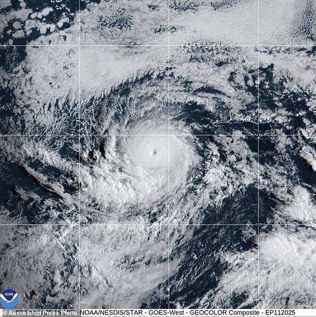
Hurricane Kiko has exploded into a Category 4 storm as it approaches Hawaii

The storm is expected to make landfall in Hawaii next Wednesday
The latest five-day forecast now has the hurricane dropping back down to a Category 1 with maximum sustained wind speeds of 75 mph as it remains hundreds of miles east of Hilo, according to the Star Advertiser.
It is then expected to make landfall in Hawaii next Wednesday, as forecasters warn even a smaller storm could drench the islands of Hawaii.
‘If Kiko continues toward Hawaii, even as a less intense tropical storm, it could bring significant wind and rain to the islands next week,’ DaSilva said.
Some reports suggest up to eight inches of rain[6] could pound the eastern side of the Big Island (Hawaii Island) once the storm hits, with around two inches predicted for the rest of the state next week.
But no watches or warnings associated with Kiko have been issued yet and there are currently no hazards affecting the land.
The last major hurricane to directly strike the state was Hurricane Iniki in September 1992.[7]
It struck as a Category 4 storm with sustained winds of 145 mph on September 11, resulting in six deaths, destroying over 1,400 homes, and causing an estimated $3 billion in damage.

The last major hurricane to directly strike the state was Hurricane Iniki in September 1992

Storm warnings and watches were in effect in Baja California, Mexico on Wednesday night as Hurricane Lorena approaches
Kiko is already the 11th named system in the eastern Pacific this year with three months left to go.
The season runs from May 15 until November 30, making it two weeks longer than the Atlantic hurricane season.
Previously, the National Oceanic and Atmospheric Administration[8] (NOAA) had predicted a ‘below-normal season’ for the eastern Pacific, with 12 to 18 named storms, five to 10 hurricanes, and up to five major hurricanes.
But another Pacific hurricane formed early Wednesday morning, Lorena, which is swirling off the coast of Mexico and could threaten states like Arizona and New Mexico this weekend.
The storm had maximum sustained winds near 85 mph Wednesday night, though it was expected to weaken and become a tropical storm on Thursday.
In the meantime, forecasters urged people on the Baja California peninsula and in northwestern Mexico to monitor the storm’s progress.
They warn that the storm could bring 15 inches of rain to some parts of Mexico, and flash flooding and mudslides were possible.
Ocean swells generated by Lorena could also cause life-threatening rip currents in coastal areas.
Tropical storm warnings and watches were in effect for much of Baja California and parts of northwestern Mexico Wednesday night in preparation for Lorena to move over land on Friday.
References
- ^ headed toward Hawaii (www.dailymail.co.uk)
- ^ crosses into the central Pacific basin on Friday (www.dailymail.co.uk)
- ^ explained to the Hawaii Tribune Herald (www.hawaiitribune-herald.com)
- ^ strengthened from a Category 2 to a Category 3 storm (www.dailymail.co.uk)
- ^ the Honolulu Star Advertiser reports. (www.staradvertiser.com)
- ^ eight inches of rain (www.accuweather.com)
- ^ directly strike the state (www.dailymail.co.uk)
- ^ National Oceanic and Atmospheric Administration (www.nhc.noaa.gov)