The predicted path of Tropical Storm Erin has made an abrupt shift overnight, increasing the chances of landfall.
Meteorologists said models now show a southward trend, aligning the storm with the Leeward Islands and Puerto Rico, along with a northern turn as it moves west through the Atlantic Ocean.
AccuWeather lead hurricane expert Alex DaSilva warned that ‘since the trend has been further south, that does increase the chance slightly of a US landfall.’
‘I still think the most likely scenario is a track somewhere between the Outer Banks [of North Carolina] and Bermuda,’ DaSilva told Newsweek.
Erin is expected to strengthen into a hurricane on Thursday and reach Category 3 status over the weekend, with winds ranging from 111 to 129 mph.
Even if the storm does not make a direct hit on the US, seas and surf will pose serious threats to coastal areas, AccuWeather warned.
The most likely track will keep Erin a few hundred miles off the US coast, but a westward shift of the Bermuda High, combined with a cold front and a dip in the eastern US jet stream, could push the storm farther west.
Meteorologists said this would increase the risk of strong winds, heavy rain, and coastal flooding in ocean-facing areas such as eastern North Carolina, Long Island, and southeastern New England.

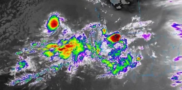
Tropical Storm Erin is moving west through the Atlantic Ocean and is expected to strengthen into a hurricane on Thursday

AccuWeather warned that the worst-case scenario would see Erin guided directly onshore, ‘packing high winds, flooding rain and storm surge flooding’
‘Interests along the East Coast of the US, the Bahamas and in Bermuda should monitor the progress of Erin, as a shift in the track could bring direct impacts to these areas,’ DaSilva said.
Erin has already left a path of destruction as the storm unleashed deadly floods over the Cabo Verde Islands on Monday, killing seven people.
The storm is currently about 3,000 miles east-southeast of the US coast, moving west near 17 miles per hour.
The National Hurricane Center (NHC) said Wednesday: ‘This general motion is expected to continue into Thursday, with a west-northwestward motion beginning Thursday night and continuing into the weekend.
‘On the forecast track, the center of Erin is likely to move near or just north of the northern Leeward Islands over the weekend.’
AccuWeather warned that the worst-case scenario would see Erin guided directly onshore, ‘packing high winds, flooding rain and storm surge flooding.’
Meteorologist Max Schuster shared on X that while the odds of a US landfall are low, ‘it cannot be ruled out still.’
‘This will likely become a major hurricane,’ Schuster added.
‘Even if this doesn’t make landfall, a close approach would still cause some problems. Still a very large spread, and details remain unclear. As it develops, the track will become clearer.’

Erin is set to be offshore Puerto Rico over the weekend. The storm is about 3,000 miles east of the US coast
As Erin intensifies, it is expected to expand, pushing huge swells outward across the Atlantic.
Read More
Scientists issue urgent warning over ‘doomsday tsunami’ set to hit parts of the US… is your hometown at risk?

Depending on its size and strength, waves could reach 30 feet or more, meteorologists warned.
As swells reach the coast, waves and rip currents will intensify. Breakers and strong rip currents will threaten swimmers from Florida’s east coast up to New England in the coming week.
‘Families heading to U.S. Atlantic beaches for a late-summer vacation next week need to be extremely cautious when venturing into the surf,’ DaSilva warned.
‘More than 50 people have lost their lives to rip currents and rough surf at beaches across the country so far this year, without any major hurricane nearby.’
From late next week into the weekend, Erin will move near Atlantic Canada, bringing heavy rain and strong winds. Rough seas will affect waters from Nova Scotia to Newfoundland