Tropical Storm Erin formed in the Atlantic Ocean on Monday as experts warned it could develop into a major hurricane this week.
AccuWeather meteorologists are tracking the storm west of the Cabo Verde Islands, saying it could become a hurricane by August 14 and intensify to a Category 3 by August 16.
Spaghetti models showed it curving northward along the US East Coast, with the potential for landfall or a close approach.
A spaghetti model forecasts possible paths a tropical storm or hurricane might take, based on predictions from multiple weather computer programs.
Senior meteorologist Chad Merrill said: ‘The upper-air pattern late this week favors it turning north and likely staying east of the US East Coast.’
‘However, rough surf and rip currents could increase along East Coast beaches next weekend into early the following week.’
A large plume of dust and dry air lies ahead of Erin, but as long as the storm stays within its current moist, dust-free area, it will continue to organize and strengthen.
‘There will be a significant increase in seas, surf and rip currents along the East coast beaches next weekend into the following week,’ Merrill said. Dangerous conditions may develop in Bermuda and parts of the Bahamas as well.

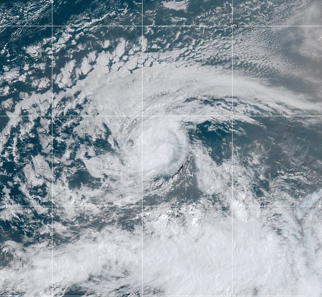
A tropical rainstorm as developed into Tropical Storm Erin, which experts predict could become a hurricane later this week

Spaghetti models showed it curving northward along the US East Coast, with the potential for landfall or a close approach
The system formed as a tropical rainstorm off the coast of Africa over the weekend, moving west toward the US.
The National Hurricane Center (NHC) on Monday morning gave it a 90 percent chance of cyclone formation over the next seven days, but predicted it would become a tropical storm today.
‘The intensity forecast in the short-term is a little tricky,’ the NHC said.
‘The earlier scatterometer data indicate the system has a small circulation, which could be prone to rapid intensity changes, either up or down.’
The agency added that ‘maximum sustained winds are 45 mph and intensification is forecast as it moves westward across the open tropical Atlantic.’
The system is moving west through the Atlantic’s ‘main development region,’ which runs from Africa’s west coast to the Caribbean.
This zone, fueled by warm ocean waters, is where many tropical systems form as hurricane season reaches its peak weeks.

AccuWeather meteorologists warned the system could soon be named Erin, potentially reaching hurricane strength by August 14 and intensifying to a Category 3 by August 16

Erin is set to become a hurricane by Friday, with a path to Florida over the weekend
AccuWeather shows dangerous sea and rip currents are set from Daytona Beach, Florida, up to Nantucket in Massachusetts.
Read More
Scientists issue urgent warning over ‘doomsday tsunami’ set to hit parts of the US… is your hometown at risk?

‘Families heading to Atlantic beaches before heading back to school should be cautious and stay in areas with lifeguards on duty,’ DaSilva added.
Should Erin grow considerably in size and strength, tropical storm conditions may extend outward 100 miles or more.
A major hurricane passing 100 miles east of the US or west of Bermuda could still bring tropical-storm-force winds, rough seas, and heavy rain.
In the US, the areas most at risk would be the easternmost stretches of coastline, including North Carolina’s Outer Banks, Long Island in New York and New England’s Cape Cod, Nantucket and Martha’s Vineyard.
Max Devitt, a meteorologist at WINKNews in Florida, shared on X: ‘Even if Erin stays offshore, it would become a powerful hurricane in the Atlantic with the potential to bring larger waves and rip currents to the US East Coast.
‘Bermuda still needs to closely monitor this system.’