Hurricane trackers warn that the odds of tropical development in the Atlantic have jumped unusually high.
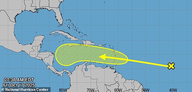
The National Hurricane Center (NHC) has given the tropical wave moving west from Africa a 30 percent chance of development over the next week, well above the typical 10 percent assigned to newly forming tropical waves.
If it strengthens, the system will be named Melissa, the next storm on the 2025 Atlantic hurricane season roster.
The tropical wave, a poorly organized cluster of showers and thunderstorms, is currently over the central Atlantic, east of the Lesser Antilles, moving west at 17 mph.
AccuWeather meteorologists warned: ‘We are tracking what may become the next threat to lives and property in the Caribbean, Central America, and potentially the U.S. before the end of October.’
Meteorologist Brian Shields, known as Mr Weatherman on YouTube[1], said that two leading forecast models indicate the system could develop into a hurricane[2].
The American GFS model predicts it could reach hurricane strength by late next week[3] as it moves through the Caribbean, potentially turning north toward the southeastern US, and the European model shows a similar scenario approaching near the Florida coastline.
Experts caution that while the exact path and intensity remain uncertain, warm Caribbean waters could fuel rapid strengthening, making preparedness crucial for coastal communities.

The National Hurricane Center says the tropical wave heading west from Africa now has a 30 percent chance of forming into a storm over the next seven days as it moves closer into the warmer Carribean waters
‘A tropical wave is located over the central tropical Atlantic,’ the NHC shared on X.
‘Gradual development of this system is possible over the next several days while it moves generally westward at 15 to 20 mph.
‘Regardless of development, this system is expected to bring heavy rainfall and gusty winds to the Windward Islands late this weekend and then move across the Caribbean Sea much of next week.’
A team of storm chasers in Florida issued a stark warning on X, saying: ‘We figured this would happen, and Florida is now in the possible 10-day track area of the tropical wave that will move into the Caribbean[4].
‘The good news is we will have plenty of time to watch it.’
Models have suggested that the tropical wave will develop into Melissa between October 21 and 25.
Meteorologists noted multiple scenarios could play out, with one steering the storm northward to Florida.

If it strengthens, the system will be named Melissa, the next storm on the 2025 Atlantic hurricane season roster

Meteorologists shared predictions, showing parts of the US that could be impacted by tropical rain and wind
‘In a worst-case scenario, the wave could organize into a tropical storm over the central Caribbean and move northward with a track near the US Atlantic coast[5],’ they warned.
However, AccuWeather noted that the tropical wave has a long way to go before entering the open waters of the Caribbean.
AccuWeather lead hurricane expert Alex DaSilva said: ‘Should the system get past issues with dry air, combative winds (wind shear), and proximity to the equator[6], it could intensify quickly once it reaches the warm and virtually untouched waters of the Caribbean next week.’

Experts have warned the blast could ‘define the Atlantic tropical season in terms of impact’
‘However, based on the anticipated weather pattern and historical records, the Caribbean could be the spot for the next tropical storm and hurricane to form and affect populated areas from next week to the end of the month,’ they said.
The Atlantic hurricane season officially continues through November 30.
As the peak period for tropical waves winds down in late October and November, new storms typically form near Central America, the central Atlantic, and the waters off the southeastern US coast.
By October 15, the season had produced four hurricanes, three of which reached major hurricane strength with sustained winds of 111 mph or higher.
In addition, there have been 12 named tropical storms and one unnamed storm of strong winds and heavy rain that impacted the US East Coast from October 10 to 14.
References
- ^ YouTube (www.dailymail.co.uk)
- ^ could develop into a hurricane (www.dailymail.co.uk)
- ^ reach hurricane strength by late next week (www.dailymail.co.uk)
- ^ move into the Caribbean (www.dailymail.co.uk)
- ^ move northward with a track near the US Atlantic coast (www.dailymail.co.uk)
- ^ get past issues with dry air, combative winds (wind shear), and proximity to the equator (www.dailymail.co.uk)