The first storm of the season is nearly upon us[1], and it’s set to be a particularly destructive one.
Experts warn that Storm Amy could become a ‘weather bomb’ – a storm that intensifies suddenly and rapidly, at an explosive rate.
A weather bomb can mean sudden violent winds of hurricane-force strength, heavy rain and flooding and potential ‘storm surges’ – huge walls of seawater by the coast.
It will mean travel disruption, power outages[2] and dangerous conditions, especially along coastlines and hills, lasting from Friday evening into Saturday.
Dr Oscar Martinez-Alvarado, an atmospheric scientist at the University of Reading, said Storm Amy could become a ‘quite remarkable’ weather bomb.
‘The low-pressure system that will become Storm Amy has only started to develop in the west Atlantic,’ he told the Daily Mail.
‘The storm is accompanied by a large amount of precipitable water – which is essentially water vapour.
‘Due to how the air moves around the storm, not only circling around but also ascending, some of that moisture will become a considerable amount of rainfall.’

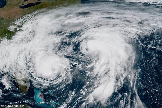
Storm Amy is developing in the wake of Hurricane Humberto, which has been churning unusually close to another hurricane, Imelda, in the western Atlantic. This GOES-19 GeoColor satellite image taken September 30 shows Hurricane Imelda, left, and Hurricane Humberto, right, in the Atlantic Ocean

The Met Office have issued a yellow warning for wind for Wales as storm Amy passes over the UK this weekend. Pictured, waves crash against the harbour wall on September 15, 2025 in Porthcawl, Wales
Dr Martinez-Alvarado explains that a weather bomb is a storm that not only develops very fast, but one in which the air pressure at its centre falls quickly.
‘This usually means the central pressure falls by about 24 millibars in 24 hours, though the exact threshold varies with latitude,’ he said.
‘Forecasts suggest Amy could deepen by around 40 millibars in the 24 hours before it reaches us, which would make it fast-developing and potentially dangerous.
‘[This] surpasses our definition of weather bomb by about 15 millibars.’
A weather bomb is to do with the jet stream – a fast moving strip of air around five to seven miles above the Earth’s surface, blowing from west to east.
Rapid acceleration of air caused by the jet stream high up in the atmosphere can remove air from the column, reducing its weight so causing pressure to fall at sea level.
This in turn sucks in air that from surrounding regions, resulting in faster and faster rotation of the circulation – much like how ice skaters spin faster by drawing their arms in.
The resulting winds peak over a period of a few hours and can be strong enough to bring down trees and cause structural damage.

A yellow warning for 70mph winds has been issued for all of Scotland, and large parts of north and west England and Wales, from 15:00 on Friday to midnight on Saturday

Storm Amy is set to bring heavy rain and strong winds to parts of Scotland, which will bring difficult driving conditions
Storm Amy is developing in the wake of Hurricane Humberto, which has been churning unusually close to another hurricane, Imelda, in the western Atlantic.
‘While Amy is not the same storm, the remnants of Humberto have helped to feed it with warmth and moisture as it turns into a mid-latitude storm on its way towards the UK,’ Dr Martinez-Alvarado added.
Although there is still uncertainty about Storm Amy’s exact track and strength, it is expected to arrive on Friday and batter western and northern parts of the UK throughout Saturday.
The Met Office has issued an amber severe weather warning for Storm Amy over parts of northern and western Scotland – meaning possible travel delays, road and rail closures, power cuts and even the potential risk to life and property.
However, Dr Jess Neumann, geographer at the University of Reading, said Brits need to ‘remain vigilant’ on Friday and Saturday wherever they live.
People should check their flood risk online using the UK government’s ‘check flooding’ webpage[3].
‘Storm Amy is forecast to bring strong winds and potentially heavy rain which could damage buildings and infrastructure, lead to localised flooding and cause severe travel delays,’ Dr Neumann said.
‘Parts of the UK which are not expected to be directly hit by Storm Amy, such as the south east will also feel the affects with some strong winds (40-50mph) and heavy rain causing disruption.
‘In parts of northern England and Scotland, recent rainfall over the past few days increases the chance of flooding and associated hazards such as landslides.’

There is still uncertainty about the storm’s exact track and strength. The Met Office has issued this graphic of the three most likely scenarios from Friday
Dr Neumann continued: ‘But don’t be tricked into underestimating the flood risk in areas that haven’t seen rain recently.
‘Intense heavy rain falling on dry soils and manmade surfaces can create a perfect storm for flash flooding.
‘Having a flood preparedness plan in place can help save lives, property and valuables.’
Storm Amy is the first named storm of the 2025/26 season, which runs from early September to late August the following year.
At the start of every September, the Met Office reveals its list of names for upcoming storms if and when they arrive in the next 12 months.
These names are alphabetized, so the first one that arrives is given a name beginning with A, the second with B, and so on.
It’s an effective system because the name of the storm and when it’s occurring instantly reveals how prolific a storm season is.
For example, during the the 2023/24 season, the UK has had its most number of named storms since the system was launched in 2015 – from Storm Agnes in September 2023 through to Storm Lilian nearly a year later.

Image issued by the Met Office of its list of 2025-2026 storm names. Amy, Bram and Chandra will be the first named storms of this winter, meteorologists revealed, after more than 50,000 suggestions were submitted by the public
Read More
Map reveals when Storm Amy’s torrential rain and 95mph gales to batter Britain

In contrast, the 2022/23 season made it only as far as the letter B, with Storm Antoni and Storm Betty, both in August.
There is ‘no clear evidence’ that climate change is increasing or decreasing the overall frequency of rapidly rotating storms, according to the Met Office.
However, there is strong evidence that increasing sea temperatures intensify these tropical storms when they develop.
Storms are becoming more intense, it’s thought, because warmer sea surface temperatures increase wind speeds.