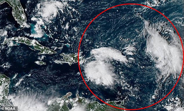
A pair of tropical cyclones forming nearing the US could soon merge in a rare weather event that could wreak havoc for millions along the East Coast.
Meteorologists fear that Tropical Storm Humberto and another potential storm in the Atlantic could get so close to each other that they start to interact, creating one massive hurricane or spinning both storms in unpredictable directions.[1]
The phenomenon is called the Fujiwhara Effect and it typically takes place when two tropical cyclones get within 900 miles of each other, close enough for them to start ‘feeling’ each other’s presence in the ocean.
The storms might rotate around a common point between them, like two hurricanes doing a slow dance.[2]
In some cases, a stronger storm might absorb a weaker one, creating an even more massive weather event[3] than either storm would have been on their own.
If they’re similar in size and strength, however, they might repel each other and get thrown in completely different directions that forecasters won’t be able to project beforehand.
These events are rare during the Atlantic hurricane season, with only a four instances taking place near the East Coast since 1995.
The National Hurricane Center (NHC) has warned that one of the tropical systems in the Atlantic, dubbed Invest 94L, has a more than 80 percent chance of developing into named storm by next week, while Humberto became a tropical storm Wednesday night.

Invest 93L and 94L are both projected to become tropical cyclones within the next week

Both storms could merge in a rare weather event that is rarely seen during the Atlantic hurricane season
Humberto has been developing in the middle of the Atlantic and forecasters have said there’s a chance it’ll become a major hurricane by Monday.
Currently under 1,000 miles from the Lesser Antilles, a group of islands in the Caribbean, meteorologists said it quickly strengthened into a named tropical storm after winds reached 39 mph, and could potentially become a hurricane if winds increase to 74 mph or higher.
As for Invest 94L, this storm system is expected to develop right off the coast of Florida.
Right now, meteorologists are more concerned with 94L, which has been growing closer to Puerto Rico and the Dominican Republic, and is still slightly behind in its development compared to Humberto.
Meteorologists added that the two storm systems appear to be forming only days apart from each other, meaning they might reach the East Coast around the same time if both keep a steady path to the US mainland.
If their paths continue to bring them closer together, the Fujiwhara Effect could start quickly after both systems officially become tropical cyclones.
The National Weather Service explained: ‘If one hurricane is a lot stronger than the other, the smaller one will orbit it and eventually come crashing into its vortex to be absorbed.’
WESH 2 chief meteorologist Tony Mainolfi added that past major storm systems like Hurricane Sandy have interacted with nearby disturbances in the Atlantic.

Humberto (pictured) is forming in the central Atlantic and has a 90 percent chance of becoming a tropical depression later this week

Invest 94L (pictured) is forming near Puerto Rico and forecasters fear it has a greater chance of striking Florida and the mid-Atlantic states
Read More
EXCLUSIVE Iconic ‘sinking city’ home to over 300,000 Americans faces terrifying new threat

Meteorologists have warned that we’ve already moved into the peak of the Atlantic hurricane season, which normally runs from September 10 through the middle of October.
However, the 2025 Atlantic hurricane season has been surprisingly quiet and has significantly underperformed expert’s predictions to this point.
Hurricane Gabrielle, which moved away from the US this week, was only the seventh named storm of this hurricane season, which has less than three months to go this year.
To this point, only Tropical Storm Chantal made landfall in the US and the massive Category 5 Hurricane Erin was the only other storm to reach hurricane status before Gabrielle.
Humberto became the eighth named storm and Invest 94L could soon be named ‘Imelda’ if it continues to strengthen.
In May, the National Oceanic and Atmospheric Administration (NOAA) predicted the Atlantic may see more than 18 named tropical storms or hurricanes this year.
References
- ^ in unpredictable directions. (www.dailymail.co.uk)
- ^ two hurricanes doing a slow dance. (www.dailymail.co.uk)
- ^ massive weather event (www.dailymail.co.uk)
- ^ #fujiwhara (twitter.com)
- ^ #weshwx (twitter.com)
- ^ pic.twitter.com/Q0cXJI4Slz (t.co)
- ^ September 24, 2025 (twitter.com)
