Millions of Americans are preparing for Hurricane Erin’s arrival offshore as forecasters warn the storm will unleash ‘large, powerful, life-threatening’ waves.
The National Hurricane Center (NHC) said Wednesday that Erin is now moving north-northwest, closer to the East Coast, but is expected to turn north and recurve, avoiding a direct US landfall.
However, the hurricane’s proximity is creating hazardous conditions along the coast. Waves of 15 to 20 feet are expected, and heavy coastal erosion is likely in North Carolina as the storm moves slowly offshore over the next several days.
North Carolina Gov. Josh Stein declared a state of emergency Tuesday in advance of the storm, delegating powers to government officials to mobilize workers and equipment along the coast.
‘To folks on the coast, now is the time to prepare,’ Stein said in a post on X. ‘Check your emergency kits, make sure you have emergency alerts turned on, and listen to emergency guidance in case you need to evacuate.’
Tropical storm conditions could spread into southeastern Virginia on Thursday, and strong winds and hazardous surf may affect the Mid-Atlantic, southern New England, and Atlantic Canada from Thursday through Saturday.
‘Erin is a large hurricane. Hurricane-force winds extend outward up to 90 miles from the center, and tropical-storm-force winds extend outward up to 265 miles,’ the NHC said.
The Category 2 hurricane’s winds weaken to 100mph on Tuesday, but the NHC predicts the storm could see its winds increase to 110mph as it passes North Carolina on Thursday.

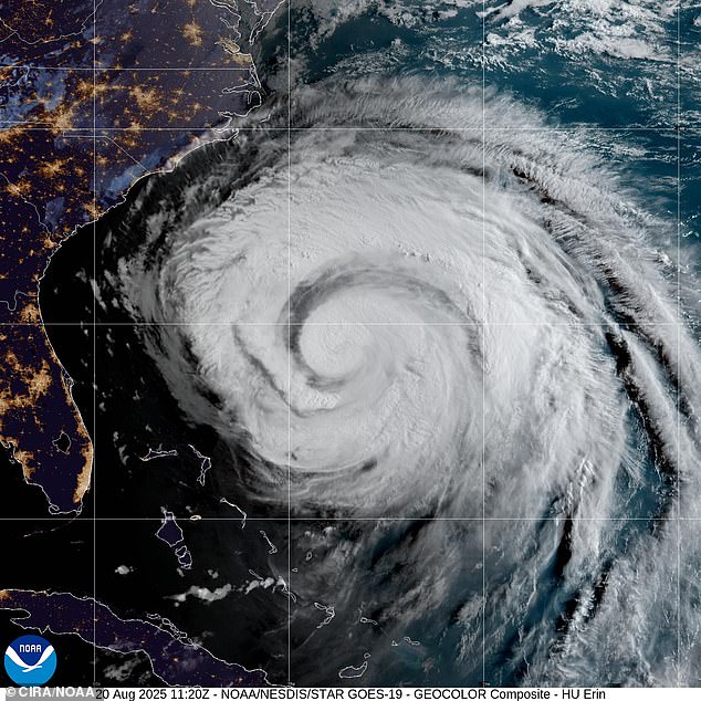
Hurricane Erin is about 450 miles east of North Carolina where officials have ordered evacuations
Erin is creating potentially deadly water conditions all along the US East Coast days before are expected, with high winds and waves anticipated in North Carolina by Wednesday night.
The hurricane was about 400 miles south-southeast of Cape Hatteras, North Carolina, and 560 miles southwest of Bermuda as of Wednesday morning.
Erin’s eye is forecast to pass about 200 miles offshore on Thursday afternoon.
Stein said the storm is expected to bring tropical storm force winds, dangerous waves and rip currents to the state.
Tropical storm conditions were expected to begin on Wednesday. At least 75 people were rescued from rip currents in Wrightsville Beach, near Wilmington, officials said.
Evacuations were ordered on Hatteras Island and Ocracoke Island on the Outer Banks.
The orders come at the height of tourist season on the thin stretch of low-lying barrier islands that jut far into the Atlantic Ocean.
There are concerns that several days of heavy surf, high winds and waves could wash out parts of the main highway running along the barrier islands, the National Weather Service (NWS) said.

North Carolina Gov. Josh Stein declared a state of emergency Tuesday in advance of the storm, delegating powers to government officials to mobilize workers and equipment along the coast

Officials warned that while Erin will likely not make landfall, the storm will unleash monster waves along the coast

Erin is on a path closer to the East Coast, but officials said it will make a sharp curve east and move out to the open sea
Warnings about rip currents have been posted from Bermuda and Florida up to the New England coast.
South Carolina’s coastal and low-country regions, including Charleston and Horry counties, are under warnings, worsened by saturated soils and potential storm surge.
New Jersey currently has no active coastal flood advisories, but heavy rainfall and potential storm surge continue to pose a risk.
A high danger of rip currents is in effect for all beaches through Wednesday evening.
Waves are expected to rise from four to six feet today, eight feet by Wednesday and 10 to 12 feet by Thursday.

Evacuations were ordered on Hatteras Island and Ocracoke Island on the Outer Banks

Dangerous rip currents are expected from Florida up into Main as Erin moves over the Atlantic Ocean this week
Several towns, including Wildwood, have closed beaches, while Avalon temporarily closed a road due to wind-driven waves.
South-facing Long Island beaches, along with Cape Cod and Nantucket in Massachusetts, could see six- to nine-foot waves near shore and 12 to 15 feet offshore, with dangerous rip currents and minor tidal flooding.
Southeast Virginia, including Norfolk and Virginia Beach, is at risk of moderate coastal flooding.
One key update is that Erin continues to grow in size, with tropical-storm-force winds now extending closer to the Mid-Atlantic and southern New England coasts later this week.