Scientists have identified the cause of a ‘mysterious tsunami’ that struck Southeast Alaska, sending water surging up slopes to 100 feet above sea level.
Early on August 10, the Alaska Earthquake Center received reports of a sudden, localized tsunami in the remote Endicott Arm area.
Waves measuring 10 to 15 feet were recorded near Harbor Island, while nearby Sawyer Island saw water climb 100 feet.
While tsunamis are typically caused by major earthquakes, scientists found no significant seismic activity in the area, deepening the mystery.
Researchers at the Earthquake Center analyzed seismic data, discovering a massive landslide near South Sawyer Glacier, with an estimated volume exceeding 3.5 billion cubic feet — the equivalent of 40,000 Olympic-sized swimming pools.
Alaska Earthquake Center director Michael West said: ‘This is larger than anything in the past decade in Alaska.’
Landslides can trigger tsunamis by displacing large amounts of water.
Alec Bennett, assistant professor at the University of Alaska Fairbanks, told the Daily Mail: ‘Events like this can be triggered in a number of ways, including seismic activity, ground thawing, or heavy rainfall.
‘Often, the landslide triggers a seismic reading, and the tsunami follows as rock, soil, and debris rapidly displace water.’

Scientists have identified the cause of a ‘mysterious tsunami’ that struck Southeast Alaska on August 10, when the Alaska Earthquake Center received reports of water surging up slopes to 100 feet in the remote Endicott Arm area
The Alaska Earthquake Center is working with other agencies ‘to understand the full sequence of events.’
On Facebook, it added, ‘All evidence suggests that this set of 10- to 15-foot waves was set in motion by a landslide of several tens of millions of cubic meters of rock striking the water.’
Portions of the landslide debris rolled onto Sawyer Glacier, while the rest tumbled into Tracy Arm, creating a seiche, a trapped tsunami within the fjord. The center said this may be the largest landslide and tsunami in Alaska since 2015.
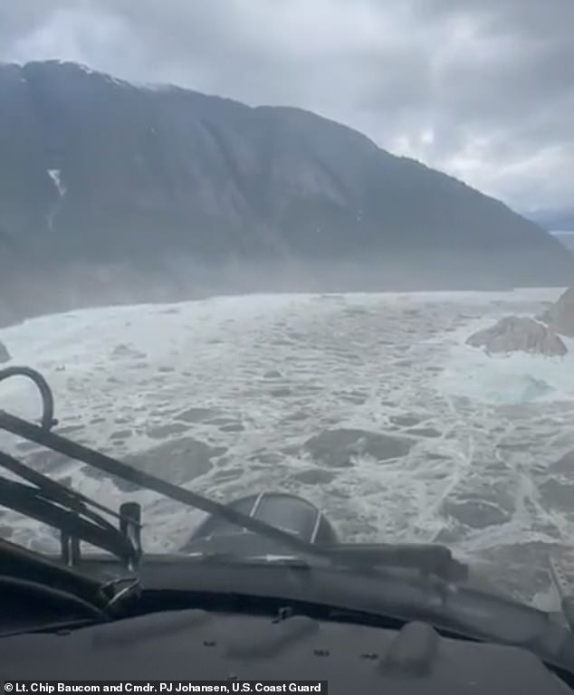
The US Coast Guard conducted an aerial survey of the landslide at South Sawyer Glacier and Tracy Arm Fjord.
Video footage shows debris strewn across the ground and a clear path of destruction down the mountainside, highlighting the event’s immense scale.
‘One thing to note is that this type of event has happened in Alaska in the past, and the 1958 Lituya Bay incident is a good example, although the resulting tsunami was much larger,’ said Bennett.
Lituya Bay experienced a massive megatsunami when a magnitude 7.8 earthquake triggered a rockslide into the narrow inlet, sending a wave that surged up to 1,720 feet, the tallest ever recorded.
The tsunami devastated the surrounding forest and destroyed boats, but remarkably, only a few people survived.
‘Narrow bays, inlets, lakes, etc., tend to be a little more prone to these since the amount of land mass can displace a larger portion of the available water quickly,’ said Bennet.

Waves measuring 10 to 15 feet were recorded near Harbor Island, and while tsunamis are typically caused by major earthquakes, water at nearby Sawyer Island climbed 100 feet despite no significant seismic activity, deepening the mystery
‘But as we go forward, the conditions that contribute to these events are likely to become more common. Fortunately, this event didn’t occur in a populated area, but as we see more of these in the future, that likelihood increases.’
The tsunami hit just days before Alaska’s capital suffered massive flooding and record-high water levels after an ice dam burst at a nearby glacier, releasing a powerful surge of rainwater and snowmelt.
Residents are urged to use extreme caution near damaged structures, stay off riverbanks, and avoid driving through standing water,’ a statement from the Juneau city website reads.
‘Officials warn that driving through flooded areas can create damaging waves that further impact nearby buildings.’

Data collected after the event shows the water likely went 100 feet up the hillside near Sawyer Island
The newly installed flood barriers, built earlier this year to protect the community from the looming ice caps, are believed to be the reason the community was spared from further devastation.
Read More
EXCLUSIVE Mysterious phenomenon that’s causing this summer to fly by… as experts reveal the devastating consequences

‘They really have protected our community,’ Juneau City Manager Katie Koester said during a news conference. ‘If it weren’t for them, we would have hundreds and hundreds of flooded homes.’
City officials responded to concerns from property owners this year by working with state, federal and tribal entities to install a temporary levee along roughly 2.5 miles of riverbank in an attempt to guard against widespread flooding.
The 10,000 ‘Hesco’ barriers are essentially giant, reinforced sandbags intended to protect more than 460 properties, said emergency manager Ryan O’Shaughnessy, The Associated Press reported.
The Juneau Assembly required homeowners in the flood zone to cover 40 percent of the cost, amounting to about $6,300 each over 10 years.
Additionally, a handful of homeowners were asked to chip in $50,000 toward reinforcing the riverbank.
Only about one-quarter of the residents formally objected, not enough to call quits on the project.
While flooding did occur, the impacts were far less severe than those seen in 2023 and 2024, when nearly 300 homes were inundated during similar glacial outburst events.

The tsunami hit just days before Alaska’s capital suffered massive flooding and record-high water levels after an ice dam burst at a nearby glacier, releasing a powerful surge of rainwater and snowmelt (PICTURED)
The devastating flooding began after water from Suicide Basin – a side basin of the Mendenhall Glacier, located about 10 miles above the state’s capital – broke free, inundating roads, damaging infrastructure, and prompting emergency warnings.
‘A glacial outburst has occurred at Suicide Basin,’ officials wrote in a statement on Tuesday afternoon.
‘The basin is releasing and flooding is expected along the Mendenhall Lake and River late Tuesday through Wednesday.’
City officials urged residents living within the 17-foot lake level inundation zone to evacuate the area immediately, adding that when the area is deemed ‘all clear,’ a wireless emergency alert will be sent to residents, Fox4 News reported.
Roads across the region were closed, including Mendenhall Loop Road, which will remain off-limits until water levels drop below 12 feet and safety inspections are complete.