Google is expanding its Earth AI platform with new Gemini-based intelligence that links environmental data with human impact in ways that used to take entire research teams to uncover. The system is being upgraded to process complex geospatial relationships so it can help scientists, city planners, and aid organizations prepare for natural disasters before they strike.
Smarter maps, faster insight
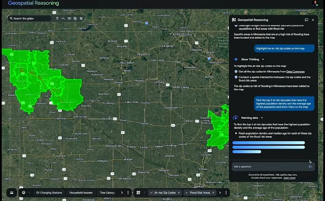
The foundation of this upgrade[1] lies in what Google calls geospatial reasoning, a way for AI to analyze satellite images, population maps, and weather forecasts in the same query. When the system processes those layers together, it can predict not only where a cyclone might land but which areas are at greatest risk and how infrastructure might respond. This form of mapping turns what once required weeks of modeling into a process that unfolds in minutes.


The model draws on years of satellite and sensor data, combining it with Gemini’s reasoning to interpret physical conditions on the ground. That means the AI can identify early signs of risk—rivers drying up, vegetation creeping near power lines, or algae spreading through reservoirs—and highlight where those patterns may threaten people or utilities. It allows agencies to act before an issue escalates.
Real-world tests already underway
Organizations like the World Health Organization’s Africa office are already experimenting with Earth AI’s population and environment models to anticipate cholera outbreaks in parts of the Democratic Republic of Congo. Energy companies are testing how the same framework can prevent blackouts by mapping tree growth near high-voltage networks, while insurers are using it to refine damage prediction models.
These tools are also being folded into Google Earth itself. Users can now type natural-language requests to find information inside satellite imagery, such as where rivers have recently dried or where algal blooms are forming. That shift makes complex geospatial analysis accessible to non-specialists who previously needed custom code or dedicated GIS software to see such patterns.
A step from reaction to prevention
Earth AI’s predictive focus reflects a wider change within Google’s environmental research, which now covers floods, wildfires, air quality, and storms. Its earlier flood forecasts reached more than two billion people, and its wildfire alerts in California helped over 15 million residents locate shelters. The latest version of Earth AI builds on that experience, seeking not to react to disaster but to forecast which communities may face the most danger and when intervention is needed.
Google has begun offering these models through its Cloud platform, letting public agencies and businesses merge their own datasets with Earth AI’s imagery and environmental layers. Thousands of groups are participating in early trials that aim to make climate forecasting, disaster response, and environmental monitoring more immediate.
If successful, Earth AI could reshape how institutions use global data. Instead of studying disasters after the fact, they might learn to see them forming in real time and move sooner to protect the people in their path.
Notes: This post was edited/created using GenAI tools.
Read next: Why AI Chatbots Aren’t Bullying Kids, But Still Pose Serious Risks[2]
References
- ^ upgrade (blog.google)
- ^ Why AI Chatbots Aren’t Bullying Kids, But Still Pose Serious Risks (www.digitalinformationworld.com)